(NCNN WeatherCenter)–The threat for tropical weather along the North Carolina coast has decreased as Tropical Depression Colin continues to weaken. The system was given the name Colin Saturday at 5 a.m. when it was named a Tropical Storm. It was expected to bring tropical conditions to the coast Saturday and Sunday, but has since weakened and the threat has diminished.
The entire state of North Carolina is under a Level 1 Risk for severe weather. Damaging wind speeds and flooding are the greatest threats from Sunday’s storm, according to NCNN meteorologist Peta Sheerwood, but hail and an isolated tornado cannot be ruled out.
While severe weather is the main threat for Sunday, Sheerwood said that Sunday won’t be a total washout. You could still find time in the sun on Sunday if you get outside early.
Severe storms are not expected to begin until around 2 p.m. in central North Carolina.
BULLETIN
Remnants Of Colin Advisory Number 5
NWS National Hurricane Center Miami FL AL032022
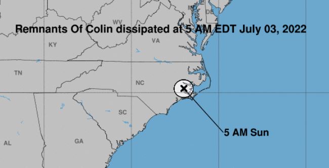
500 AM EDT Sun Jul 03 2022
…COLIN DISSIPATES OVER EASTERN NORTH CAROLINA…
…THIS IS THE LAST ADVISORY…
SUMMARY OF 500 AM EDT…0900 UTC…INFORMATION
LOCATION…35.2N 77.0W
ABOUT 10 MI…15 KM NNE OF NEW BERN NORTH CAROLINA
MAXIMUM SUSTAINED WINDS…30 MPH…45 KM/H
PRESENT MOVEMENT…NE OR 55 DEGREES AT 10 MPH…17 KM/H
MINIMUM CENTRAL PRESSURE…1014 MB…29.95 INCHES
WATCHES AND WARNINGS
CHANGES WITH THIS ADVISORY:
None.
SUMMARY OF WATCHES AND WARNINGS IN EFFECT:
There are no coastal watches or warnings in effect.
DISCUSSION AND OUTLOOK
At 500 AM EDT (0900 UTC), the remnants of Colin were located near latitude 35.2 North, longitude 77.0 West. The remnants are moving toward the northeast near 10 mph (17 km/h) and are expected to turn east-northeastward and accelerate soon, emerging over the Atlantic waters east of North Carolina this afternoon.
Maximum sustained winds are near 30 mph (45 km/h) with higher gusts, occurring mainly over the Atlantic waters off the North Carolina coast.
The estimated minimum central pressure is 1014 mb (29.95 inches).
HAZARDS AFFECTING LAND
Key messages for the remnants of Colin can be found in the Tropical Cyclone Discussion under AWIPS header MIATCDAT3 and WMO header WTNT43 KNHC.
WIND: Gusty winds are still possible over the North Carolina Outer Banks this morning.
RAINFALL: Scattered showers and thunderstorms may impact coastal North Carolina through this morning. Most areas will see less than an inch of additional rainfall.
SURF: Swells continue to affect portions of the North Carolina coast and could cause life-threatening surf and rip current conditions through this evening. Please consult products from your local weather office.
NEXT ADVISORY
This is the last public advisory issued by the National Hurricane Center on this system.