(NCNN WeatherCenter) — Much of North Carolina, including Wayne County, is under a Level 2 risk for severe storms this evening.
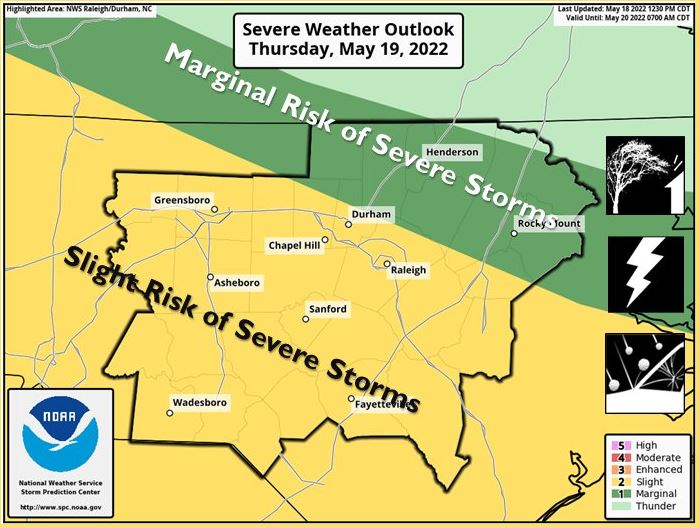
An update released Wednesday afternoon showed most counties in the Triangle area and south were under a Level 2 risk. Franklin, Nash and Person counties were all in the Level 1 risk area.
People north of the Triangle may not see a lot of storms.
“This is really an event impacting the Triangle southward,” NCNN meteorologist Elizabeth Gardner said.
The Level 2 risk indicates severe storms will likely be scattered, not widespread, and short-lived.
It was already warm and muggy Thursday morning, a perfect setup for severe storms later in the day, according to Gardner.
A few showers will be possible Thursday morning and midday, but scattered storms look more likely after 3 p.m., with the better chance for stronger storms from about 5 p.m to midnight.
“Round 1 will be during the evening commute, and then we’ll see a break, and Round 2 arrives between 11 p.m. and 2 a.m.,” Gardner said.
Damaging winds will be possible, but there is not a great risk for tornadoes, Gardner said.
Temperatures will climb into the 90s Thursday for the first time this year, and the weather will be even warmer for Friday and Saturday.
Friday’s high, expected to be 96 degrees, could break the record of 94 degrees set in 1938. Friday and Saturday should remain dry, although there will be another chance for rain Sunday and Monday.
“A few showers are possible Friday afternoon and evening, but these will remain spotty and most areas will stay dry,” NCNN meteorologist Zach Maloch said.
Another cold front arrives Sunday and Monday, bringing an end to the 90s and cooler weather for next Monday and Tuesday.


