(NCNN WeatherCenter)–Parts of central and Eastern North Carolina will be under a Level 1 risk for severe weather on Thursday as the remnants from Zeta pass through the area.
Highs will be in the mid to upper 70s on Wednesday with partly cloudy skies. By Wednesday afternoon, skies will become gray as remnants from Zeta approach North Carolina. There is a 30 percent chance we’ll see some showers start to move into the area by Wednesday night.
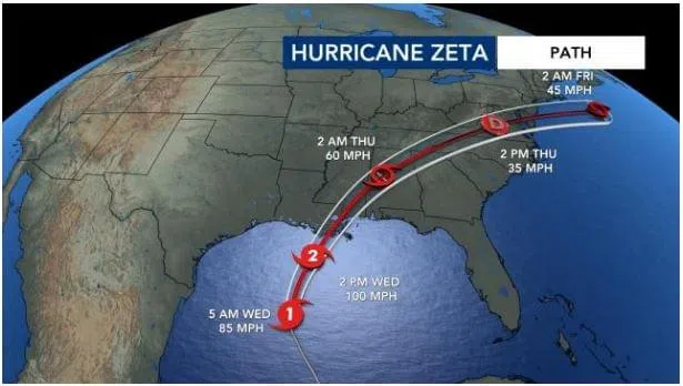
Hurricane Zeta is expected to impact the northern Gulf Coast states as a Cat. 2 hurricane by late Wednesday. Landfall is possible anywhere from Louisiana to the Florida panhandle.
Storm surge between 6 to 9 feet is possible in places along with as much as 8 inches of rain. Zeta is expected to move over the Gulf Coast quickly, which is good news for those states, NCNN meteorologist Elizabeth Gardner said.
Remnants of the storm could then bring about 1 inch of rain to North Carolina Thursday, although new models indicate central North Carolina may see more windy conditions than rain. Winds could gust as much as 60 mph north of the Triangle, creating damage and possible tornadoes. Rain is also likely but areas north and west of the Triangle are likely to see more of it.
By Thursday night, the remnants will be moving northeast of the Triangle and a cold-front will sweep by on Friday, which will bring cooler weather for the holiday weekend. The low pressure is expected to be right behind the remnants of Zeta.