(NCNN WeatherCenter)–A Flash Flood Watch is in effect for Central of North Carolina for Thursday and Friday, and counties south of Raleigh are under, a Level 2, or elevated, risk for severe weather.
Tropical Storm Sally will cause a remnant low that will be south of North Carolina. Rain will be possible all day on Thursday and the first half of Friday.
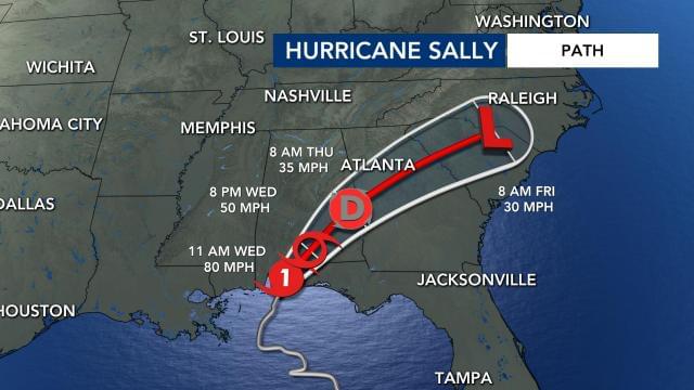
Southern North Carolina is in the path of the end of Hurricane Sally.
The heaviest rain will be with us tomorrow late afternoon, evening and night.
As of 2 p.m. on Wednesday, Sally was moving north-northeast at about 5 mph with maximum sustained winds of 70 mph. It made landfall in Alabama at around 6 a.m. on Wednesday.
“We can’t rule out the possibility of a few isolated tornados at the center of circulation from Sally’s remnants near our southern counties,” said NCNN meteorologist Aimee Wilmoth.
Southern counties in North Carolina are under a severe weather risk for Thursday.
On Thursday, central North Carolina is under a low to medium risk for excessive rainfall.
We are expecting 3 to 6 inches of rain in the state over the next three days.
We are looking at getting 3 to 6 inches of rain over the next couple of days, according Gardner. Some pockets of the state could get as much as 8 inches of rain from Sally.
North Carolina is going to see flooded roads and rivers will likely rise from heavy rain.
Thunderstorms should move out of our area by Friday night.
While Sally’s impact on the Gulf Coast could be severe, impacts in North Carolina will be minimal apart from the risk for flooding. According to the National Weather Service while most models keep the Neuse River below flood stage, a good number of them take the river above minor flood stage at Clayton, Smithfield, and Goldsboro on Friday and Saturday.

We are under a medium risk for excessive rainfall for Thursday.
Since the weather is still nice outside for most of Wednesday, now is the time to start preparing for very heavy flooding.

